Even in the age of GPS, alternate forms of navigation are still around, and still in use. One such technology is VOR (Visual Omni Range) navigation. Despite the questionable acronym, VORs provide useful navigational information by allowing users (nearly always aircraft) to determine their bearing to or from a given nearby station. With two such bearings, position can be determined reasonably accurately.
This direction-finding ability relies on the combination of two signals from the VOR: an omnidirectional reference signal and a swept unidirectional phase signal. By determining the phase difference between the signals, a receiver can determine the direction to the VOR. If the phase signal is received at the same time as the reference signal, the receiver is north of the VOR (since the phase signal is tuned to match the phase of the reference signal when directed north.) If the signals are 180 degrees out of phase, the receiver is to the south. One degree of phase difference corresponds to one degree of azimuth.
Theoretically, given a list of VOR frequencies and locations (readily available online), a GPS-like navigation device could be built to automatically scan the band from 108-118MHz, find nearby VOR signals, determine bearings to them, and solve for the position. Once the phase information is extracted from the signals, solving for receiver position is fairly straightforward. (Aircraft-based navigation systems such as the FMCs on some Boeing aircraft, do this; the FMC can sometimes be seen tuning VORs along the flight path automatically to supplement GPS/INS navigation.
Unfortunately for hobbyist investigations, VORs are specifically designed not to radiate significant RF power at ground level. To minimize interference with other radio services, VOR transmitters include a ground plane at 10′ height, which serves to minimize radiated power at low angles. The specified “service volume” for VORs generally starts at about 1000′ AGL (Above Ground Level).
This makes collecting VOR signals tricky unless you have access to an airplane (or perhaps if you go to the trouble to mount a RPi and a RTL-SDR radio on a quadcopter.) Signal strength, and therefore readability, drop off quickly within a short distance of the VOR, unless you can somehow manage to be at a higher altitude.
This lack of low-altitude signal availability means that VOR navigation is impractical for ground navigation. However, receiving and decoding VOR signals is still a useful exercise — and with the increasing reliability of GPS and other global satellite-based navigation systems such as GLONASS, VOR transmitters may not be around for much longer.
So, to capture a VOR signal for analysis, a field trip was in order. If the VORs won’t transmit appreciable power at ground level, the only option that doesn’t involve chartering an airplane or duct-taping half a kilo of RF gear to a drone is to go pay one a visit.

The Bangor (BGR) VOR transmitter, showing the central omnidirectional antenna, the surrounding phased array, and the groundplane.
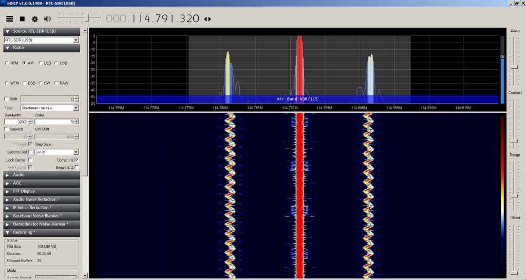
Counterpoise or no, this close to a VOR, you can get a beautiful signal from ground level, even using a $20 RTL-SDR kit from Amazon and SDRsharp software.
The next step (which will have to wait until I can take a closer look on my workstation) is decoding the signals. One of the nicer features of SDRSharp is its ability to record a slice of the radio spectrum for later playback.
…But be careful what you ask for. Quadrature sampling at 32 bits produces four bytes of data per second, per Hertz of bandwidth sampled. At 16,000kb/sec, this is roughly 2MB per second. At higher speeds, it’s even worse. Roughly ten minutes of recording produced several GB of data, before I realized I didn’t have to sample half the nav spectrum.
This post is dedicated to the memory of my grandfather, Millard C. Carr, who would have been 100 years old today, and who would have thoroughly enjoyed the idea of homebrew VOR navigation, even if he would have pointed out that it’s simpler to use GPS. We miss you, Granddad.


